


Zevtt - Le Blanc 2012

kipoura
Gebruiker

Lengte
51 km

Max. hoogte
125 m

Positief hoogteverschil
638 m
Km-Effort
59 km

Min. hoogte
67 m

Negatief hoogteverschil
638 m
Boucle
Ja
Datum van aanmaak :
2019-05-03 17:10:30.667
Laatste wijziging :
2019-05-03 17:10:30.757
3h00
Moeilijkheid : Medium

Gratisgps-wandelapplicatie
 SityTrail
IGN / Geografische instituten
SityTrail Plus
De wereld gaat voor u open
Over ons
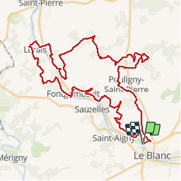
Tocht Mountainbike van 51 km beschikbaar op Centre-Val de Loire, Indre, Le Blanc. Deze tocht wordt voorgesteld door kipoura.
Beschrijving
Une superbe boucle VTT au départ de Le Blanc, au dessous du viaduc. Circuit très ludique et technique ... http://zevtt.free.fr
Plaatsbepaling
Land:
France
Regio :
Centre-Val de Loire
Departement/Provincie :
Indre
Gemeente :
Le Blanc
Locatie:
Unknown
Vertrek:(Dec)
Vertrek:(UTM)
351037 ; 5167044 (31T) N.
Opmerkingen